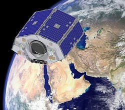
Earth observation satellite captures ground images in unprecedented detail
Surrey, England--NigeriaSat-2, a 300 kg class Earth observation satellite manufactured by Surrey Satellite Technology Ltd (SSTL) for the Nigerian space agency (NASRDA), has released its first high-resolution satellite imagery.
Incorporating a 2.5 m resolution panchromatic imager as well as a 5 m resolution multispectral imager with a swath width of 20 km, NigeriaSat-2's camera with a Cassegrain design captured 2.5 m resolution images to enable detailed analysis of ground structures, aircraft, and vehicles. The camera's optical components (from Optical Surfaces Ltd.) include a 385 mm lightweight primary mirror and other optics with a surface accuracy of λ/20 p-v, enabling the satellite to capture the high-resolution images.
During disasters, NigeriaSat-2 will complement its fellow Disaster Monitoring Constellation satellites by using its camera to "zoom in" on areas of interest and determine if individual buildings are damaged, if bridges are destroyed, or if roads are impassable. NASRDA also plans to harness the satellite's new capabilities and fast image downloading to map the entire country in detail every four months. The high resolution and geo-location accuracy of the satellite make it possible to monitor urban development in sprawling cities such as Lagos, and for planning infrastructure such as roads. Geospatial data will also be used to update the land registry with accurate and current information.
NigeriaSat-2 is also the first satellite in the African Resource Management (ARM) constellation.
-----
Subscribe now to Laser Focus World magazine; it's free!
