LASER SCANNERS: High-definition surveying plays increasing role in disaster recovery
At 3:42 a.m. on April 29th, a tanker truck carrying more than 8600 gallons of gasoline crashed on the “MacArthur Maze,” a heavily traveled approach to the San Francisco-Oakland Bay Bridge. The crash ignited a 3000°F fire that softened the steel frame of the freeway enough that the eastbound Interstate 580 connector fell onto the Interstate 880 connector below it.
In the repair effort, a 165 ft segment of eastbound 580 had to be demolished, new steel girders and a concrete support column constructed and installed, and 200 cubic yards of concrete poured for the deck. Both freeways were fully restored within 26 days.
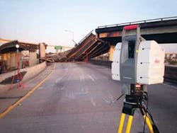
As part of the investigation that began as soon as it could safely be performed, the California Highway Patrol (CHP) Multidisciplinary Accident Investigation Team (MAIT) collected laser-scan data from the ground to the top of the destroyed overpass (see figure). Recording of forensic evidence took place at the same time as contractors were demolishing the overpass. The process of fully documenting the scene ended after midnight.
Laser scanning is finding increasing use for damage assessment and forensic surveys in what Geoff Jacobs, senior vice president of strategic marketing at Leica Geosystems (Norcross, GA), describes as “high-end” incidents, involving potentially large lawsuit settlements, high-visibility incidents such as terrorist actions, or incidents in which a valuable asset has been damaged and must be quickly returned to normal use.1
Prominent examples include investigations of the Princess Diana accident in a Paris underpass; analysis of the USS Cole explosion, the Bali resort bombing, and the London Underground and bus bombings of 2005, as well as surveying damage to oil and gas platforms damaged by Hurricane Ivan in 2004. The MacArthur Maze crash last spring is a case in which laser scanning enabled rapid data gathering, as part of an overall effort to repair a valuable public asset and return it quickly back to service.
Jacobs notes several key factors for the growth in value of laser scanning in high-profile forensics and damage assessment. High data-point density has become essential for documenting highly irregular surfaces of the type that are common in damage assessment, while ultrafast data capture aids in situations where cleanup and repair must begin immediately. Remote, reflectorless measurement, as well as the potential for robotic operation, are valuable in dangerous situations. In addition, 3‑D visualization enables computer-generated imagery to provide views of a structure from angles or perspectives that might otherwise be impossible to obtain, and the potential for imagery with enhanced information processing (such as false coloring) can provide structural information otherwise invisible by simply viewing a potentially damaged structure or area.
Lt. Dave Fox, MAIT’s team manager, said the laser scanner greatly increased the workers’ data-collection productivity and provided them with a much denser dataset than they could gather with conventional methods. “The ScanStation enabled us to be very mobile and efficient while collecting very detailed data,” he said. “Typically we can acquire 500 to 1000 points; with Leica’s 3-D laser we collected millions. We couldn’t have collected that kind of information without laser scanning.”
Laser scanning also enabled the CHP to collect data more safely, said Tony Grissim, Leica Geosystems’ forensic account manager. “There were many areas at the scene where it was unsafe to walk,” he said. “Since Leica’s ScanStation allows you to acquire data remotely, MAIT officers could document critical sections of the infrastructure from a safe distance.”
REFERENCE
1. G. Jacobs, Professional Surveyor Magazine25(11) (November 2005); www.profsurv.com/archive.php?issue=106&article=1506.
Hassaun A. Jones-Bey | Senior Editor and Freelance Writer
Hassaun A. Jones-Bey was a senior editor and then freelance writer for Laser Focus World.
