Editor’s Note: This is the first article in a new series in which contributing editor Stephen J. Matthews will discuss various aspects of image engineering.
The first days of 2004 witnessed the nearly simultaneous arrival of two spacecraft at Mars. The new probes joined two satellites that are already in Martian orbit collecting data. These multiple missions are evidence of the heightened interest in the Red Planet that was revived several years ago by the discovery of possible fossils in a Martian meteorite, together with the increasing likelihood that water may be distributed beneath the Martian surface.
Exploring Mars, however, has been troublesome. After a hiatus of 20 years, NASA returned to Mars in the 1990s, only to see the costly and disheartening failure of three out of the five missions in the decade. Together with mission failures by the Russian and European Space Agency (ESA), this experience led to a reevaluation of the exploration program and revised design and development approaches.
Spirit has landed
The first of the new generation to successfully reach Mars was the ESA’s Mars Express, which entered orbit in December 2003. The other missions are the twin rovers from NASA—Spirit, which landed Jan. 3, and Opportunity, scheduled to land later in January—as well as the troubled Japanese orbiter, Nozomi. Mars Express is less than half the size and much less than half the cost of the failed NASA missions, thanks in part to its use of spare parts left over from earlier ill-fated efforts.
Mars Express includes a small nonroving lander named Beagle 2 (which, at press time, appeared to have failed) that was designed to search for water and organic material at its landing site. The orbiter itself will use sounding radar to scan for water below large areas of the Martian surface. Orbiters usually carry a wide variety of instruments for remote sensing, with imaging systems playing the most central role. The most fundamental data these systems provide is the topographical image, the “relief map,” of the planet’s surface.
For this purpose, the High/Super Resolution Stereo Color Imager (HRSC) on board the Mars Express will photograph the surface in detail as small as two meters. One method of producing topographical images results from the stereo viewing (anaglyphic or other method) of pairs of photographs taken during one orbital pass with about 50% overlap of the field of view. Photo pairs with a similar overlap from adjacent orbital paths can also be used.
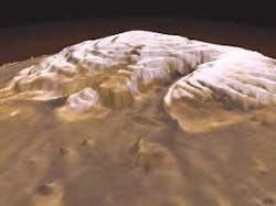
Elevations at individual points taken from such data can be used to calculate a Digital Elevation Model, which can then be combined with the satellite photographs to produce a three-dimensional image (see Fig. 1). Some cameras can tilt sufficiently off-angle from the nadir (the point directly below the satellite) to obtain a 3-D image directly. The HRSC system is based closely on technology used for aerial mapping of Earth (the camera is available for rent).
Meanwhile, back on Earth
Of the approximately 2400 satellites that have been sent into Earth orbit, about 100 have been privately funded, and most of these have been launched for communications. A shift toward the commercialization of imaging satellites started in 1989 with the privatization of the Landsat program (although responsibility for Landsat bounced between agencies for several years). But the real turning point in the commercial availability of satellite images resulted from the collapse of the Soviet Union.
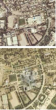
To raise foreign capital, the new Russian government began selling satellite photos previously withheld from distribution because of military security. Images of just about any location on Earth at 2-m resolution became available for a few thousand dollars (see Fig. 2). Security issues are still a concern—photographs of troop movements, for example, can be available even to opposing armies at war, as was the case last year in Iraq.Nevertheless, demand for these images has fueled private funding of satellites and launch vehicles. By and large, these are still joint ventures between governments and industry, with new programs in China, South Korea, and Japan joining long-established programs in France, India, and Britain. As one example, the U.K. Ministry of Defense and the British National Space Centre is funding TopSat, one of a new generation of so-called microsatellites.
TopSat
Following its launch later this year, the TopSat camera will sweep a panchromatic image area 15 km2 at about 7 km per second. Images will be available directly to local users via downlink from the satellite. TopSat weighs only about 100 kg, but should produce photographs that are state-of-the-art thanks in part to ongoing advances in CCD imaging.
A common technique used by spacecraft for image acquisition is so-called “pushbroom imaging.” A linear CCD array samples a cross section of the image almost instantaneously in the visible and near-IR. The array signal is discharged and the data stored fast enough to allow the next incoming scan resulting from the forward progress of the satellite to be detected independently. As the linear CCD array advances with the spacecraft’s orbital motion, successive lines of data accumulate to form the image.
Achieving the planned 2.5-m resolution for the TopSat field of view would normally require a large aperture. However the small size of the satellite constrains the aperture to 20 cm, which increases the exposure time beyond the acceptable limits for pushbroom imaging. To compensate, the apparent motion of the field of view over the ground is slowed by slewing the camera platform.
This is a simple form of the general technique of Time Delay Integration (TDI), which typically uses a two-dimensional array or multiple CCDs to increase resolution and signal-to-noise ratio by increasing the exposure. As a spacecraft moves above the surface, the integration time for one line of the CCD is set to match the ground velocity. The signal in the first line is then shifted into the next line of the CCD at the same rate that the image moves—that is, the charge in a pixel is sequentially clocked into the corresponding pixel of the next line in the along-track direction.
This allows charge from multiple CCD pixels to produce a single pixel in the image. A line rate of 10,000 lines/s corresponds to a line time of about 100 µm for 250-km altitude. The satellite is slewed to prevent image smearing during the integration period, while the performance of the spacecraft pointing jitter places a practical limit on the number of times a line can be shifted.
TopSat is designed to take pictures up to 30° off-nadir, and its 600-km Sun-synchronous orbit will be able to revisit any location within six days. The TopSat camera, built by Rutherford Appleton Laboratory (Oxford, England), is an all-reflective design that uses three mirrors in sequence, the first and third of them off-axis hyperbolic surfaces. Its design illustrates the need for excellent radiometric performance from modern satellite cameras used for hyperspectral imaging.
Hyperspectral imaging
Hyperspectral data is reflected sunlight divided spectrally into hundreds of discrete bands, typically about 10 nm wide in the visible and near-IR, for every pixel in an image. By comparing the spectra to calibration data, the composition and other material properties of the field of view can by obtained at the resolution limit of the imaging system. While the resolution will be lower than (typically less than half) a panchromatic image, the additional spectral content can produce a startling level of detail.
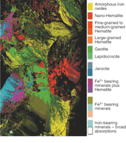
Higher-resolution hyperspectral images, for example, are used to create natural-resource inventories in unprecedented detail (see Fig. 3). Other fields such as oceanography can require less spatial resolution. Oceanography makes use of the color from chlorophyll in surface water, which in turn depends on the concentration of marine life, surface temperature, and so on. Hyperspectral scans of the sea in broad spatial resolution are being used in a range of studies, including ozone depletion, the dynamics of hurricanes, and management of fishing industries.One conceptually straightforward method for gathering hyperspectral data is to use a spectrometer to disperse the incoming light over one dimension of a two-dimensional CCD array, with the other dimension used to capture the spatial image in pushbroom fashion. The result is a three-dimensional array of data called (somewhat misleadingly) a hypercube. Separate but precisely aligned CCDs can also be used for different spectral ranges.
Infrared spectra, which can be captured using such CCDs as a mercury cadium telluride (HgCdTe) array cooled to 115K, are especially useful in the study of minerals at or just below the surface. Such mineral deposits, including those formed in water such as hydroxides and hydrothermal silica, have unique identifying signatures in the infrared. Carbonates, sulfates, nitrates, and alteration minerals such as oxides have spectral features near 2.3 µm and also between 3 and 5 µm.
“Follow the water”
The search for water using such indirect methods is the foremost mission of NASA’s program in unmanned spaceflight. Data most recently sent by the orbiter Mars Odyssey indicates fewer water-related minerals than expected, based on the evidence that channels in the topography were probably carved by water flows in the planet’s past. Greater resolution is needed than is available from Mars Odyssey, whose IR spectral images provide nine spectral bands at 100-m resolution.
Accordingly, Mars Reconnaissance Orbiter will examine spectral data from the Martian landscape as small as 18 m from an altitude of 300 km. Close approach to Mars comes about every 26 months, each time Earth overtakes Mars in its solar orbit. The shortest trajectory for the trip brackets this time, so launch for the Mars Reconnaissance Orbiter is planned for August 2005, about ten weeks before the next close approach.
NASA has adopted the slogan “follow the water” for its progressive search for the location of water in the solar system. Water, most likely in the form of ice, could provide the basis for permanent human settlement, not only as drinking water but also as a source of oxygen for breathing and hydrogen for fuel. But of course the excitement that underlies this search is the hope of finding evidence of life.
Stephen J. Matthews | Contributing Editor
Stephen J. Matthews was a Contributing Editor for Laser Focus World.


