Photonics innovations in climate observation: A view from Europe
Scheduled for launch in 2025, the European Space Agency’s (ESA) Carbon Dioxide Monitoring Mission (CO2M) will measure the amount of carbon dioxide released into the atmosphere through human activity. The payload includes a treasure trove of photonics technologies:
- a telescope with polarization scrambler and entrance slit homogenizer
- a reflective collimator, common for all bands
- glass (VIS/NIR) and silicon (SWIR-1/SWIR-2) imagers
- Mercury-Cadmium-Telluride CMOS detectors in SWIR
- Si CMOS detectors in VIS-NIR
The effort is among the latest in a long list featuring European photonics companies and organizations that are gathering and providing invaluable insights about environmental changes, adding precision and depth to our understanding of the Earth’s changing climate and playing a pivotal role in shaping the future of climate observation and environmental preservation strategies. Here, we highlight many of them.
Assessing the market
These companies and organizations seek to solve complex challenges that address increasing concern about the global impact of climate change, which is driving the demand for quality and precision data on Essential Climate Variables (ECVs; see “Measuring climate changes”). A recent market report1 projects the environmental monitoring market will grow from USD $12.4 billion in 2023 to USD $18.9 billion by 2032, a compound annual growth rate of 5.40%.
Measuring climate changes
The Global Climate Observing System (GCOS) currently specifies 55 Essential Climate Variables (ECVs) in three main categories and subcategories:2
1. Atmosphere
a. Surface, Upper air: includes precipitation, pressure, temperature, and wind speed and direction at different altitudes
b. Upper Atmosphere: covers aerosols, carbon dioxide, methane and other greenhouse gases, and ozone
2. Land
a. Hydrosphere: e.g., groundwater and lakes
b. Cryosphere: e.g., glaciers and ice sheets
c. Biosphere: e.g., above-ground biomass, albedo (the fraction of light that the Earth’s surface reflects), and surface temperature
d. Anthroposphere: the part of the Earth system that is made or modified by humans for use in human activities and human habitats); i.e., greenhouse gas fluxes and water use
3. Oceans
a. Physical: e.g., ocean surface heat flux, sea ice and level, surface currents, salinity, and temperature
b. Biogeochemical: e.g., inorganic carbon, nitrous oxide, oxygen
c. Biological/ecosystems: i.e., marine habitats and plankton
Satellite-based systems
An effective way of obtaining ECV data is via LiDAR and hyperspectral imaging technology on board aerial systems and satellites, where broader coverage provides a more detailed picture of Earth’s changing temperature, sea levels, atmospheric gases, and declining ice and forest cover.
With the reduction in costs and increase in launch availability, today’s satellites are often deployed in low Earth orbits (LEO) as constellations only 500 to 1000 kilometers above the Earth, which, compared with satellites in high or medium Earth orbits, enables them to capture smaller areas with enhanced detail.
The European Space Agency (ESA) has been at the forefront of satellite-based climate monitoring programs since 1999 with the Aeolus mission, the first satellite capable of performing global wind-component-profile observation. Aeolus’s payload was the ALADIN instrument (Atmospheric Laser Doppler Instrument), a direct detection ultraviolet laser LiDAR consisting of a transmitter, a Mie receiver to determine winds from aerosol and cloud backscatter, a Rayleigh receiver (Fabry-Perot etalon) to determine winds from molecular backscatter, and a 1.5-m-diameter Cassegrain telescope.
In 2012, ESA established the Copernicus program, which included seven Sentinel missions that provided all-weather, day-and-night radar imaging for land and ocean services; high-resolution optical imaging of vegetation, soil and water cover, inland waterways, and coastal areas; and data on sea and land ECVs. Future Sentinel missions will provide data on atmospheric composition monitoring of nitrogen dioxide, ozone, sulfur dioxide, formaldehyde, glyoxal, and aerosols. Monitoring will be achieved via UV-visible and NIR infrared spectrometry with an 8 km spatial resolution and 60-minute repeat cycles.
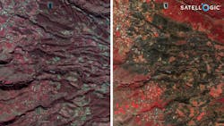
In parallel, companies like Satellogic, founded in 2012 and based in Barcelona, provide affordable and high-quality data from space to enable organizations to track daily changes on the Earth’s surface with sub-meter resolutions. The company currently has 34 operational satellites in orbit providing multispectral imaging of the Earth with a spatial resolution of 0.70 to 0.99 m.
Critically, Satellogic’s proprietary multispectral cameras allow the monitoring of selected points of interest weekly, and the use of different spectral bands provides expanded insight into the level of environmental damage, especially of the biosphere (see Fig. 1).
Hyperspectral cameras
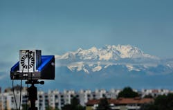
NIREOS, an Italian company, designs and manufactures interferometers, hyperspectral cameras, and photodetectors. Its HERA range of hyperspectral cameras are powerful tools for climate monitoring, thanks to their ability to capture hyperspectral images over a wide spectral range (400–2200 nm) with high spectral and spatial resolutions (see Fig. 2). Currently, the HERA hyperspectral cameras are widely employed to assess vegetation health, aiding scientists in tracking and understanding climate patterns and characterizing microplastics, a critical environmental challenge with potential consequences for the ecosystem. HERA cameras also represent an essential tool in material science for characterizing novel technologies and materials, such as perovskite tandem solar cells, which promise to improve energy production and storage.
Infrared cameras
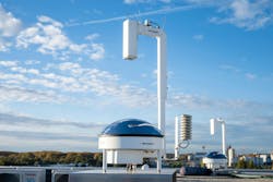
Reuniwatt, a French company headquartered on Reunion Island in the Indian Ocean, specializes in cloud observation and forecasting. It has patented an infrared all-sky imager—the Sky InSight—that can continuously track and forecast cloud cover. With this device, an infrared camera films a hemispherical mirror to capture the cloud ceiling with a 180° angle corresponding to a 2-km radius. Various cloud cover parameters are then obtained by processing the sky temperature map.
In 2022, the Sky InSight was used together with a ceilometer, disdrometer, sodar, microwave sounder, tethersondes, and radiosondes in the DYVALOCCA project, a collaboration between French, German, and Gabonese research organizations (see Fig. 3). The aim was to monitor the evolution of clouds and evaluate their effects on water and light availability in the dense evergreen forests on the Atlantic coast of Central Africa, which are particularly vulnerable to climate change, as any reduction of these low clouds may represent a major tipping-point for forest cover and functioning.
Optical filters and components
In climate change monitoring, optical filters and components play a vital role. These technologies, adept at manipulating light wavelengths, are essential for enhancing the accuracy of satellite-based observations. By filtering specific wavelengths and ensuring precise imaging, optical filters and components enable us to monitor Earth's climate with unprecedented detail. Optical filters provide wavelength selectivity to the sensing instruments in which they are employed. In Earth Observation (EO) systems, optical filters can serve as either single bandpass filters (BPFs) to interrogate one wavelength region of interest or as multi-zone filter (MZF) arrays that can turn a single detector into a multispectral device capable of analyzing a range of wavelengths.
HOYA, headquartered in Japan and with production sites in Europe, Asia, and the US, produces a range of optical filters for space applications, including filters for 1550 nm LiDAR sensing applications and AR-coated neutral density filters to facilitate constant attenuation across a range of wavelengths.
Iridian Spectral Technologies, a Canadian-based company, designs and manufactures custom EO optical filters and filter arrays to allow sensing instruments to discriminate specific signal wavelengths from competing signals or backgrounds. Their filters are used in satellite-based EO instruments; for example, in ESA’s Meteosat Third Generation Lightning Imager (MTG-LI) to enable the observation of weather patterns, pollution, or natural disasters such as the eruption of the Tonga submarine volcano in 2021.
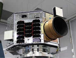
Tecnottica Consonni, based in Milan and established in 1957, specializes in designing and manufacturing lenses, optical systems, optical components, filters, and mirrors for industrial, automotive, biomedical, and aerospace applications. In 2020, the company manufactured the sub-components for the NEMO-ND, a 72 kg microsatellite developed jointly by the Slovenian Centre of Excellence for Space Sciences and Technologies and the University of Toronto Institute for Aerospace Studies. The project aimed to combine real-time multispectral and video imaging from space, thus providing a revolutionary concept of Earth observation (see Fig. 4).
Tecnottica’s contribution was the production of absorption filters to remove part of the signal from UV light and SWIR light and all the lenses embedded on the telescope to enable precision monitoring of climate changes, natural disasters, and the sustainable use of natural resources.
Vortex Optical Coatings, located in the UK and founded in 2008, specializes in IR filters for monitoring greenhouse gases, such as CO2, refrigerant gases, hydrocarbons, and sulfur hexafluoride. Its IR filters, 25 mm in diameter and 0.5 mm thick, are placed in front of system detectors to sensitize the system to measure the candidate gas. The filters can be manufactured to extremely tight tolerance, and by using sputtering technology they are much more stable and durable than their evaporation technology counterparts of 10–20 years ago.
Sensors
Photonics-based sensors play a crucial role in climate change monitoring, providing precise and comprehensive data on essential climate variables. From satellites to UAVs, these sensors enable us to capture detailed insights into temperature changes, sea-level rise, greenhouse gas concentrations, and ecosystem dynamics.
An underlying driver of the Earth’s climate is the interplay between the Sun’s UV radiation in the Herzberg continuum (200–242 nm) and oxygen/ozone in the upper atmosphere. However, continuous, and accurate measurements of UV solar spectral irradiance cannot be measured from the Earth because the Earth’s ozone layer blocks transmission of the Herzberg continuum. To overcome this problem, in April 2023, the French university Versailles Saint-Quentin-en-Yvelines launched a mini satellite (UVSQ-SAT) to demonstrate technologies for broadband measurements of Earth Radiation Budget (ERB) and for Solar Spectral Irradiance (SSI) in the Herzberg continuum.
A partner in this program is the French SME Nanovation, which has successfully developed ground-breaking gallium (III) oxide (Ga2O3) UVC sensors that can measure wavelengths below 250 nm. Because of their intrinsic solar blindness and state-of-the-art gain, these compact solid-state sensors do not need high operating voltages and have been shown to be highly reliable and robust to heat/cold, vibrations, and radiation. As a follow-on project, ESA has engaged Nanovation to develop a Ga2O3 imaging array for early warning and localization of wildfire ignition from low earth orbit.
Climate change and air pollution are closely interlinked. Apart from being the cause of premature deaths, air pollutants such as carbon dioxide, methane, and nitrous oxide deplete the ozone layer and cause acid rain. Similarly, particulate matter from diesel engines can end up in the polar regions darkening the ice and snow, thereby contributing to global warming.
New Infrared Technologies (NIT), a Madrid-based manufacturer of uncooled midwave-infrared (MWIR) and longwave-infrared (LWIR) detectors, cameras, systems, and solutions for industrial and defense applications, is a partner in the EU’s FLAIR project. FLAIR was set up to develop an airborne air quality sampling sensor to detect gases in 2–5 μm (methane, carbon dioxide, carbon monoxide, nitrogen oxides) and 8–12 μm (nitrous oxide, ammonia, ozone) infrared atmospheric windows. NIT’s contribution to the project was the TACHYON 16K +, a high-speed (>4000 fps) uncooled MWIR camera in the spectral range of 1.0 µm to 5.0 µm. Thanks to its lightweight and compact form factor, the whole system including a data processing algorithm can be deployed in a UAV for the risk assessment of multi-species atmospheric gases.
Mapsi Photonics, based in Barcelona and created in 2021, is focused on the manufacture and commercialization of infrared optical components (filters and windows) for industrial applications related to gas identification and process monitoring (see Fig. 5).
Mapsi’s filters and windows are 100% silicon and are not multilayer, as they are made by perforating the silicon with nanometric pores with a very low-cost production process. In this way, it takes full advantage of the outstanding optical and mechanical properties of silicon. The filters are especially effective at long wavelengths, where the absorption of gases with high environmental impact (methane, SF6) and ammonia present their fundamental absorption.
Substrate materials
Substrate materials constitute a cornerstone in the field of climate change monitoring, providing the foundation for precise and reliable satellite imaging systems. These specialized materials, engineered to withstand the rigors of space, play a pivotal role in ensuring the stability and accuracy of Earth observation missions. Substrate materials enable the creation of high-resolution cameras and mirrors essential for monitoring environmental changes.
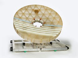
To deliver precise images and measurements, satellites require high-resolution cameras with mirror substrate materials that can deliver stable optical performance despite the temperature fluctuations of low earth or geostationary orbits. Headquartered in Mainz, Germany, SCHOTT manufactures specialty glass, glass-ceramics, and other advanced materials, including their near-zero thermal expansion glass/ceramic ZERODUR (see Fig. 6). This mirror substrate material is an inorganic, non-porous lithium aluminum silicon oxide glass-ceramic, characterized by its extremely low thermal expansion, which is homogeneous throughout the entire volume. Additionally, compared with other glass-ceramics, it’s stronger, possesses a lower rate of imperfections, and is transparent to visible light.
ZERODUR is currently being used as mirror substrates in the flexible combined imager of EUMETSAT’s innovative Meteosat Third Generation (MTG) satellite system. This satellite has 16 spectral channels and can deliver a full image of Earth every 10 minutes to track changes in atmospheric water cycles and provide better weather reporting and predictions of natural disasters.
The future of climate observation
The European Space Agency is planning various Quantum Missions (2023-2031) that will use a new generation of quantum sensors to enhance the measurement of ECVs as well as helping to scale up scientific and industrial R&D and creating a vibrant and innovative European ecosystem in quantum technology.
One of the objectives is to improve the measurement of gravity because tiny variations in the strength of the Earth’s gravity field have been shown to affect dwindling freshwater resources, the loss of ice mass from ice sheets and glaciers, and changes in sea-level, and therefore on climate change.
The idea for future quantum sensors is to combine the principles of current gravimetry measurements with cold atom interferometry, which involves using lasers to freeze atoms within the instrument to near absolute zero (-273.15°C). Then, switching off the lasers allows the atoms to move freely in response to the strength of the gravity field. Measuring the phase difference through interferometry as the atoms ‘fall’ according to the pull of gravity will provide measurements of the gravity field as the satellite orbits around Earth.
Although the theory of using quantum gravity sensors in space to measure gravity is relatively simple, until now, the challenge is to develop a robust satellite technology that provides the mission lifetime and high-resolution coverage required. To this end, ESA is working with NASA on the MAGIC gravity constellation, whose objective is to measure variations in the Earth’s gravitational field with a close temporal frequency (every three days) and a spatial resolution of 100 km.
REFERENCES
1. See https://tinyurl.com/5n78fusy.
2. See https://tinyurl.com/5n7w8ct9.
About the Author
Jérémy Picot-Clémente
Jérémy Picot-Clémente is photonics technologies manager for the European Photonics Industry Consortium (EPIC), and is based in Auvergne-Rhône-Alpes, France.

