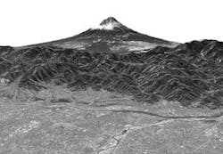
REMOTE SENSING: Advanced Land Observing Satellite returns first images
Image data of Mt. Fuji were collected as part of an initial functional verification test from the Advanced Land Observing Satellite (ALOS) of the Japan Aerospace Exploration Agency (JAXA; Tokyo, Japan) in mid-February using the Panchromatic Remote-sensing Instrument for Stereo Mapping (PRISM). A 3-D movie was compiled from the image data and the first images released for public viewing early in March. Obtained less than one month after the ALOS launch in January (much quicker than is typical for sophisticated imaging systems), the images show objects as small as cars; the stereo imaging—a unique capability for an Earth-observation satellite—allows generation of 3-D “fly-by” movies.
Goodrich (Charlotte, NC) developed the optical systems in the three PRISM payload telescopes, which have an optical configuration allowing them to capture large areas on the ground. The lightweight mirrors in each system measure 0.6 m in maximum dimension and are polished to a surface precision of better than 10 nm.
In addition to the PRISM system for digital elevation and mapping, the ALOS has two other remote-sensing instruments. The Advanced Visible and Near Infrared Radiometer type 2 provides precise land coverage observation, and the Phased Array type L-band Synthetic Aperture Radar provides day-and-night and all-weather land observation.
The Japanese Earth-observing satellite program consists of two series: those satellites used mainly for atmospheric and marine observation, and those used mainly for land observation. The ALOS follows the Japanese Earth Resources Satellite-1 and Advanced Earth Observing Satellite and will use advanced land-observing technology. The ALOS has five mission objectives: to provide maps for Japan and other countries including those in the Asian-Pacific region; to perform regional observation for sustainable development and harmonization between Earth environment and development; to conduct disaster monitoring around the world; to survey natural resources; and to develop technology necessary for future Earth observing satellites.
About the Author
Hassaun A. Jones-Bey
Senior Editor and Freelance Writer
Hassaun A. Jones-Bey was a senior editor and then freelance writer for Laser Focus World.
