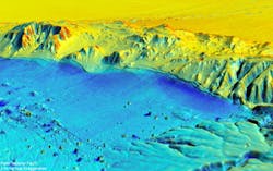
LIDAR used to map Mexicali magnitude 7.2 earthquake zone in 3D
Davis, CA--Michael Oskin, a geologist at the University of California, Davis, is lead author on a recent Science journal paper that describes how a team of scientists from the U.S., Mexico, and China used differential absorption LIDAR (light detection and ranging) to report the most comprehensive three-dimensional (3D) before-and-after pictures yet of an earthquake zone using data from the magnitude 7.2 event that struck near Mexicali, Mexico, in April 2010.
The team, working with the National Center for Airborne Laser Mapping (NCALM), flew over the area with LIDAR equipment and made a detailed scan over about 140 square miles in less than three days. Oskin said that they knew the area had been mapped with LIDAR in 2006 by the Mexican government. When the earthquake occurred, Oskin and Ramon Arrowsmith at Arizona State University received rapid-response funding from the National Science Foundation (NSF) to carry out an immediate aerial survey to compare the results.
Paper co-authors John Fletcher and Orlando Teran from Mexico's Ensenada Center for Scientific Research and Higher Education (CICESE) carried out a traditional ground survey of the fault rupture, which helped guide planning of the aerial LIDAR survey and interpretation of the results.
From the ground, features like the five-foot escarpment created when part of a hillside abruptly moved up and sideways are readily visible. But the LIDAR survey further reveals warping of the ground surface adjacent to faults that previously could not easily be detected, Oskin said. For example, it reveals folding above the Indiviso Fault running beneath agricultural fields in the floodplain of the Colorado River. "That would be very hard to see in the field," Oskin said. By comparing pre- and post-earthquake surveys, they could see exactly where the ground moved and by how much.
More images can be viewed at www.nsf.gov/news/news_images.jsp?cntn_id=123073&org=NSF.
SOURCE: R&D Magazine online;www.rdmag.com/News/2012/02/Information-Tech-Geology-Imaging-Laser-maps-show-before-and-after-of-quake-zone-in-3D/

Gail Overton | Senior Editor (2004-2020)
Gail has more than 30 years of engineering, marketing, product management, and editorial experience in the photonics and optical communications industry. Before joining the staff at Laser Focus World in 2004, she held many product management and product marketing roles in the fiber-optics industry, most notably at Hughes (El Segundo, CA), GTE Labs (Waltham, MA), Corning (Corning, NY), Photon Kinetics (Beaverton, OR), and Newport Corporation (Irvine, CA). During her marketing career, Gail published articles in WDM Solutions and Sensors magazine and traveled internationally to conduct product and sales training. Gail received her BS degree in physics, with an emphasis in optics, from San Diego State University in San Diego, CA in May 1986.
